Toyota C-HR Hybrid in Tenerife: Our Driving Review
 Mia Andersen
7 min read
 Oliver Thompson
Ready to rent a car in Tenerife?
The northeast corner of Tenerife looks completely different from the dry resorts in the south. When you drive up into Anaga Rural Park Tenerife, the landscape shifts dramatically. Jagged green peaks rise straight out of the Atlantic Ocean. Thick clouds roll over ancient forests. It feels like a prehistoric world, yet it is only an hour away from the capital city of Santa Cruz.
Exploring this UNESCO Biosphere Reserve requires some planning. The roads are steep and twisting. Public transport is sparse and infrequent. Having your own vehicle is essential if you want to stop at the best viewpoints and reach the remote black sand beaches on the northern coast.
The Anaga mountain range is one of the oldest parts of Tenerife. It formed through intense volcanic activity about seven to nine million years ago. Over the millennia, rain and wind carved deep ravines into the basalt rock. These deep valleys are known locally as barrancos. They channel rainwater down to the sea and create a unique microclimate.
Before the Spanish conquest in the 15th century, the Guanches lived in these mountains. These indigenous people of the Canary Islands used the deep caves for shelter and kept flocks of goats on the steep hillsides. You can still see the agricultural terraces they started. Later generations expanded these terraces to grow crops in an unforgiving landscape.
Today, the high ridges catch the trade winds blowing in from the northeast. This interaction creates a constant sea of clouds that blankets the upper slopes. The moisture from these clouds drips down into the soil, sustaining a lush ecosystem that contrasts sharply with the arid southern coast. You will see giant ferns, moss-covered rocks, and endemic species of birds like the Bolle’s pigeon.
Most visitors arrive on the island via Tenerife South Airport. If you plan to explore the northern mountains during your trip, picking up a vehicle right after you land makes the most sense. You can arrange your car hire directly at TFS and hit the road immediately.
From the airport, take the TF-1 motorway north. The drive to Santa Cruz takes about 45 minutes. The motorway is wide, well-maintained, and easy to navigate. Once you pass the capital, the real adventure begins. You will follow the TF-11 along the coast to the fishing town of San Andres. At San Andres, you turn sharply inland onto the TF-12. This road climbs rapidly into the mountains and serves as the main artery through the park.
Driving the TF-12 gives you spectacular views of both the northern and southern coasts. It winds along the spine of the mountain range. You will want to take your time and pull over frequently to appreciate the scenery.
If you approach the park from the university city of La Laguna via the TF-113, your first major stop will be Mirador de Jardina. This viewpoint offers a sweeping look back over the Aguere Valley. On a clear day, you can see the perfect cone of Mount Teide looming in the distance. The contrast between the flat valley floor and the sudden rise of the Anaga mountains is striking.
A few kilometres further along the TF-12 sits Cruz del Carmen. This is the main hub for visitors. It features a large parking area, a small cafe, and an information centre. The viewpoint here looks out over La Laguna and Santa Cruz. This is also the starting point for several of the most popular hiking trails in the reserve. The parking lot fills up very quickly by 10:00 AM. Arriving early is the only reliable way to secure a space.
Take a short detour off the TF-12 onto the TF-114 to reach Pico del Ingles. This is arguably the most famous viewpoint in the entire park. A narrow ridge extends out into the valley, giving you a 360-degree panorama. You can look down into the deep ravines that cut through the green mountainsides. Photographers love this spot at sunrise when the first light hits the jagged peaks.
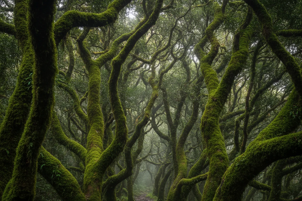
Anaga is famous for its laurisilva. This type of subtropical forest covered much of Southern Europe millions of years ago. Now, it only survives in a few places like the Canary Islands, Madeira, and the Azores. The trees have twisted trunks covered in thick moss. The canopy is so dense that very little sunlight reaches the forest floor.
Stop at the Cruz del Carmen visitor centre to experience the forest up close. You can walk the Sendero de los Sentidos from here. This Trail of the Senses is an easy, well-marked path through the trees. It takes about 45 minutes to complete the longest loop. The air up here is cool and damp. You will want a light jacket even in the middle of August. The path smells strongly of wet earth and bay leaves.
After exploring the high ridges, take the TF-134 down towards the coastal village of Taganana. This descent is breathtaking. The road hugs the cliffside, dropping steadily towards the ocean. You will pass through tiny hamlets where farmers grow potatoes and vines on impossibly steep terraces.
The road requires concentration. It features dozens of tight hairpin bends. You will often need to slow down to a crawl to pass oncoming local buses safely.
At the bottom of the descent, the road levels out along the rugged northern coast. Stop at Playa de San Roque to stretch your legs. There are a few small restaurants here serving excellent fresh fish right by the water. Drive a little further east to reach Almáciga. This small village sits slightly above a beach that is very popular with experienced surfers. The waves here are powerful and the currents are strong, so swimming is rarely advisable.
The paved road finally ends at Benijo. Playa de Benijo is widely considered the most beautiful wild beach on the island. You have to walk down a long set of wooden stairs to reach the sand. The black volcanic beach contrasts sharply with the white foam of the crashing waves. Huge rock formations, known as Roques de Anaga, stand just offshore. It is an incredible place to watch the sunset before you start the drive back to your accommodation.
While the driving route is spectacular, getting out of the car allows you to truly experience the silence of the laurisilva. The park offers hundreds of kilometres of marked trails.
For an easy stroll, the Sendero de los Sentidos at Cruz del Carmen is perfect for families. It uses an old royal road that once connected the remote villages to La Laguna. If you want a moderate challenge, the trail from Chamorga to Roque Bermejo takes you to the far eastern tip of the island. You leave your car at the end of the TF-123. The path drops down a dramatic ravine to a tiny coastal hamlet that is completely inaccessible by road. You will see a small lighthouse and a quiet black sand beach. The hike back up is steep and requires a reasonable level of fitness. Always carry plenty of water, as the humidity in the forest makes you sweat more than you might expect.
The roads in Anaga are fully paved but very narrow in places. You absolutely do not need a 4×4 to explore the area. A standard compact car is usually the best choice for navigating tight corners and squeezing into small parking spaces at the viewpoints.
If you want to make the drive a bit more special, consider looking into luxury and convertible options. Driving through the mountains with the roof down gives you a completely different perspective of the towering forests above you.
Here is a rough guide to what you can expect to pay for car rental Tenerife in 2026. Prices fluctuate based on demand, but these averages will help you plan your budget.
| Car Class | 2026 Average Price (Low Season) | 2026 Average Price (High Season) | Best For Anaga Driving |
|---|---|---|---|
| Compact (e.g. VW Polo) | 25-35 EUR/day | 45-60 EUR/day | Easy parking at busy viewpoints |
| Mid-size SUV (e.g. Nissan Qashqai) | 40-55 EUR/day | 70-90 EUR/day | Extra comfort on the TF-1 motorway |
| Convertible (e.g. Mini Cooper Cabrio) | 65-85 EUR/day | 110-150 EUR/day | Panoramic views of the forest canopy |
| Minivan (7-seat) | 75-95 EUR/day | 130-180 EUR/day | Large families travelling together |
Driving the TF-12 and TF-134 requires your full attention. The speed limit is usually 40 km/h or lower. Locals know the roads well and may drive faster than you feel comfortable with. If a local driver comes up close behind you, simply pull over at the next safe spot and let them pass. This reduces stress for everyone.
Many visitors wonder whether to rent a manual or automatic car. An automatic transmission makes navigating the steep inclines much easier. You will not have to worry about clutch control on a 15% gradient if you get stuck behind a slow-moving bus. However, manual cars are often cheaper to rent. Choose whatever you feel most comfortable driving at home.
Parking is a major challenge. The lots at Cruz del Carmen and Pico del Ingles fill up very early. If the main lot is full, do not park on the blind corners or block the road. The local police patrol these mountain routes regularly and will issue fines to illegally parked vehicles.
Watch out for the weather. The mountains create their own microclimate. You might leave Santa Cruz in bright sunshine and drive straight into a thick fog bank near the summit. Use your fog lights if visibility drops below 50 metres. Be careful on wet leaves, as the tarmac can get surprisingly slippery under the forest canopy.
Finally, make sure you have enough fuel. There are zero petrol stations once you enter the park boundaries. Fill up your tank in Santa Cruz, San Andres, or La Laguna before you start your climb.
If you drive straight from San Andres to Cruz del Carmen and back down to La Laguna, it takes about an hour. You should allow at least four to five hours to include viewpoint stops, a short hike, and a detour down to Benijo beach.
The roads are well surfaced but feature many blind bends and steep gradients. Drivers who are nervous about heights might find the drop-offs intimidating. Take your time, stay in a low gear on the descents, and you will be absolutely fine.
You can drive the main roads and visit most viewpoints without any paperwork. A few specific hiking trails, like El Pijaral, require a free permit from the Tenerife Cabildo. These permits book up weeks in advance online.
You will find several excellent local restaurants scattered throughout the park. Casa Africa in Roque de las Bodegas is a reliable choice for fresh seafood. A full meal for two typically costs around 35-45 euros.
Early morning is the best time. The light is fantastic for photography, the parking lots are empty, and the tour buses have not yet arrived. Late afternoon is also beautiful, especially for watching the sunset from the northern beaches.
Exploring the ancient forests and dramatic coastlines of the north is a highlight of any trip to the Canary Islands. Having a reliable vehicle gives you the freedom to set your own pace and discover hidden corners that buses cannot reach. If you need to arrange your transport, check out our main car hire Tenerife page to find the perfect vehicle for your holiday.
Car rental at Tenerife South Airport (TFS) → · SUV hire in Tenerife → · Compact car hire in Tenerife →
Planning your Tenerife trip?


 Camila Fernández
 Carlos Ramirez


 Mia Andersen
 Camila Fernández
The minimum chargeable car rental period is 24 hours. If you specify a return time later than the time you received the car, 1 rental day is added.
 Isabella Rossi
 Sophie Dubois